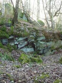
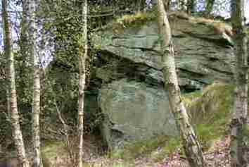
Rocks and Geology
The geology of Buck Wood underlies everything we see on the surface. Most of the history of the wood, ancient and modern, has happened as a consequence of what lies underneath the trees and fields we see today. It is a complex story of ice ages, fault lines, tropical forests (with a surprising number of fossils), and multiple layers of rocks.
Please click here to access an illustrated report on the geological past of Buck Wood.
The Ecology of Buck Wood
The Friends of Buck Wood had a role not only in maintaining the woodland, but also tried to improve the diversity of the wood by, for example, adapting and developing small areas to take advantage of existing natural resources. This included activities such as planting native species of bushes, bulbs and flowering plants, whilst also reducing the effect of invasive species such as Himalayan Balsam and Spanish Bluebells.
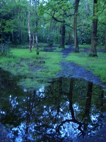
On a larger scale, one particular continuously muddy area, created by one of the natural springs referred to previously, was developed into a marshy wetland site by the Friends, with help from the Yorkshire Wildlife Trust and other volunteers. This has enhanced the range of habitats in the Wood as a whole, and encourages more wildlife to the woodland.
The NVC Survey
The ecological survey of Buck Wood which the Friends of Buck Wood commissioned in 2005 was a major component of the ‘Breath of Fresh Aire’ project, for which we received a grant from the Local Heritage Initiative. The aim of the project was to compile data on many aspects of the Wood, past and present.
The survey was conducted by Geoffrey Wilmore, Consultant Ecologist, consultecol.wilmore@btinternet.com
The Buck Wood survey was carried out using the National Vegetation Classification (NVC) scheme. This concluded that the woodland fell largely into two major NVC types which are related to the differing acidity of the soil overlaying the Millstone Grit. In some areas, especially the woodland adjoining Ainsbury Avenue, there is a mixture or mosaic of the two types.
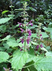
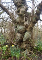
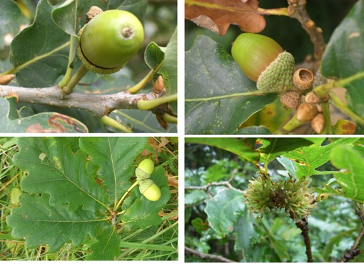
In the less acidic areas (type W10 in the NVC) pedunculate oak, silver and downy birch, and planted beech are the main trees, along with a few rowans and abundant holly. The herb layer in these areas tends to be dominated by bracken, bramble and creeping soft-grass. Bluebells are plentiful, along with wood millet, hedge woundwort and ferns.
On the steeper valley side a more acidic soil is found. In this area (type W16) sessile and hybrid oaks are more common, along with silver and downy birch, some holly but with few other trees and shrubs. The herb layer is poor but contains the characteristic wavy hair-grass.
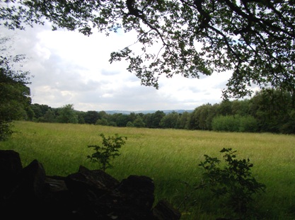
The fields, with their long history of grazing, are relatively species poor (MG6 according to the NVC) However the plants present include several grasses such as yorkshire-fog and cat’s ear, and flowers including self-heal and black medick.
The woodland has come under considerable human pressure in recent years. However, it still contains representative samples of two NVC types showing good regeneration of the major trees and shrub species, and is an important reservoir for wildlife.
The complete Ecological Survey, including lists of plants, animals etc. of Buck Wood, can be accessed here.
The National Vegetation Classification
The ecological survey of the Wood categorised all the different areas of the woodland according to the National Vegetation Classification scheme. This is the system of identifying and documenting the vegetation of all natural, semi-natural and major artificial habitats in Great Britain, excluding Northern Ireland. It uses a standard description of meticulously classified vegetation types, and has been widely employed since the 1970s.
The National Vegetation Classification is based on one fundamental idea: that areas of vegetation should be chosen which are uniform in composition and structure.
How NVC surveys are carried out
To use the NVC system at any given site, the survey procedure is as follows:
1. An initial walk-over survey is carried out to identify, by eye, stands or areas of the same vegetation, e.g., of woodland, grassland etc., where various ‘indicator’ species occur regularly throughout the stand.
2. Having identified such an area of vegetation, random quadrats (square frames) are thrown in order to record and document the plant species occurring within each quadrat. The size of quadrat used varies with the type of vegetation
3. Within each quadrat, each plant species identified is recorded using a special ‘Domin’ scale as a measure of the frequency with which it is found.
4. The NVC system includes a computer program in which all the thousands of national samples taken during the NVC Project have been stored and analysed. The sample data from the survey are fed into the program and compared with the 33,000 national samples to arrive at a ‘best fit’ or ‘best match’ to the appropriate plant community.
National Vegetation Communities
The major vegetation communities in the NVC system are given code letters, such as W for Woodland, H for Heaths, S for Swamps, and amongst various types of grasslands, MG for Mesotrophic or Neutral Grasslands.
Within each group are further subcommunities, which are numbered.
The results for Buck Wood show that there are two dominant types of Woodland, W10 and W16. These are both types of mixed deciduous woodland with different species of oak featuring strongly – but the ground cover is also different in the two communities, so they are distinguishable by their grass or flowering plants. Some parts of the Wood are a mosaic of the two types.
The fields within Buck Wood are all classified as MG6, which is Mesotrophic or Neutral Grassland, further classed as being ‘semi-improved’. This is one of the most common categories of grassland, associated with the fields having been used as pastures and meadows, both in the past and at present.
Some sections of Buck Wood cannot be surveyed by the NVC system because there is or has been too much interference by man. This includes the plateau where the bike track now is, which was formed by tipping when the railway tunnels were being excavated, and the swathe of flat land adjacent to the bridle path above the canal which is regularly clear cut because of the power lines and pylons above it.