A part of Buck Wood’s history
On this page is a summary of the history of Buck Mill. If you would like to find out more, please click here buck_mill_history_2019.pdf for a more detailed history of the Mill, with additional maps, more pictures, and something about the lives that were bound up with the Mill.
If you enjoyed reading about the history of the Mill, you can find more detail of both past and present by clicking buck_mill_walkover_survey.pdf. This survey is richly illustrated with photos and drawings of most of the features of Buck Mill that have survived, as well as maps and plans of the buildings and other structures that played a role in the long and complex growth of the site.
Please note that all information on these pages and links is copyright, and should not be reproduced without permission and acknowledgement. fobw@ncalvin.f9.co.uk
Buck Mill: a brief history
Whilst Bradford and its surrounding hamlets were growing and forming connections, until the Middle Ages Thackley and its woodlands were still isolated. They were also remote from the rest of the Township of Idle, of which they were part. But despite its situation Buck Wood became a focus for the inhabitants of Idle, because that was where the manorial corn mill was built, on the bank of the River Aire. There, the flow of the river was diverted through a ‘goit’ or mill race to turn the water wheel.
The mill belonged to the Lord of the Manor, and everyone in the area was required to take their corn to the mill for grinding. Some of the tracks and paths that exist today were probably formed by generations of local people carrying their annual harvest of grain to the Mill to be ground into flour. The Lord of the Manor received rent from the miller who was his tenant, and the charge for grinding the corn provided income for the miller.
It is also recorded that as early as 1567 the Mill had diversified, and was also being used for processing woollen cloth. By 1584 the corn and fulling mills and the house attached to it were occupied by the Buck family, which led to the Mill becoming known as Buck Mill. At that date they also held various pieces of land nearby.
The Buck family prospered, and their house down by the river next to the Mill was one of the largest in Idle. In the early seventeenth century they bought 120 acres of the East Wood, which covered the valley side above the Mill. This woodland became known as Buck Wood. The Wood and the Mill were held in private hands, including the Calverleys of Esholt Hall and their successors the Stansfields, until 1906.
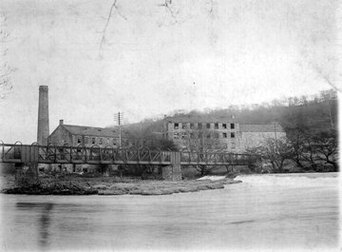
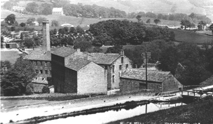
By the mid-eighteenth century the Mill no longer had a monopoly for grinding corn, so the emphasis of its production changed towards the wool trade, as part of Bradford’s rapidly increasing primary industry, and alongside other mills in Idle and Thackley. The Stansfield family rebuilt the Mill around 1800, adding a scribbling mill to the corn and fulling mill.
Benjamin Thornton, who also owned Bowling Green Mill in Thackley and Albion Mill in Idle, rented Buck Mill in the 1860s. He built a new warehouse and wool-washing room, which consisted of two large four-storey blocks, along with a boiler house, engine and chimney.
By this time the machinery was powered by steam rather than water wheel. To conserve water for the boiler a dam was made in a field across from the mill. The remains of this can still be seen as a rectangular shape in the field on the opposite side of Buck Mill Lane.
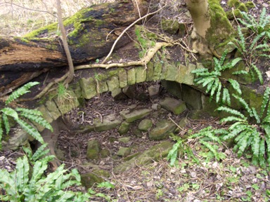
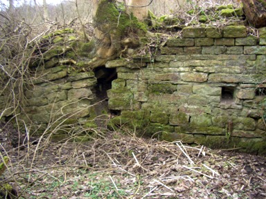
By 1905 the Mill was described as ‘Disused’ on official maps. For some years before the 1914-18 War the mill was empty and becoming increasingly derelict. Finally, in 1923 the buildings were blown up and a quantity of the stone was used to pave Buck Mill Lane. which climbs the hill to Thackley.
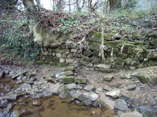
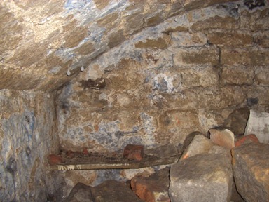
Foundation stones of the mill complex were still visible within living memory, but are now more or less completely overgrown, and the area has become unsafe because of long term problems with water leakage from the canal directly above. When the river level is low it is possible to see some early stonework, and elements of the goit and its construction.
A document showing the development and decline of Buck Mill through maps illustrates both the growth of the site and the changes that took place in the flow of the River Area over several centuries of association with the Mill and the river crossing adjacent to it.